Friday 30 May 2014

Some Sefton Rambles


The place name Sefton is of Saxon origin and is descriptive of the low-lying land of the parish which in earlier times would flood every winter. The name might be translated as settlement by the sedges or rushes. After the Norman Conquest this land was conferred upon William de Moline or Molyneux and the Sefton (or Moline) cross, which now serves as the logo for Sefton Metropolitan Borough, was the heraldic emblem of the Molyneux family.


Early representations of the Moline Cross can be seen carved in the entryway to St Helen's Church in the old village of Sefton.


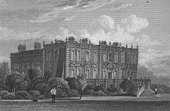
 Sefton lies on the river Alt which in former times was a more substantial waterway than we find today. It was navigable as far as Croxteth, a ninth century Norse settlement about nine miles upriver, where in 1575 Molyneux, by this  time Earl of Derby, moved into the newly built Croxteth Hall. This remained the family seat until 1972 when the seventh and last earl died. At this time the estate was acquired by the city of Liverpool .


River Alt at midsummer sunrise.


The norse name Croxteth derives from Croc's Staithe or landing place and many other place names in this part of south west Lacashire bear witness to the viking influence in this area. When the nearby M62 motorway was being built in 1975 evidence of this of this was confirmed when the remains of a viking longboat were uncovered during earth moving at theTarbock exit.


 Over recent centuries the meadows of the Alt plain have undergone significant improvement and former peat mosses are now good quality agricultural land. Even so, until the construction of floodgates at Altmouth in 1830 the river remained tidal as far as Showrick Bridge by Sefton village and even with the present complex nexus of drainage ditches and pumping stations the Alt can still be capricious. As Alison Maddock in her 1999 study asserted: this "small river [bears] influence on life and livelihood in the area out of all proportion to its size".


In the last couple of years and after prolonged debate a radical flood prevention scheme has been implemented. This has involved the surrender of improved farmland in favour of the creation at Lunt Meadows of 70 hectares of permanent reedbed and floodplain grazing marsh. This is designed to alleviate the threat of flooding to the nearby township of Formby by allowing the Alt to overspill in a managed way as and when the situation demands. At such times a significant diversion of the river might be achievable. When the Environment Agency has completed its work, the management of Lunt Meadows will pass to Lancashire Wildlife Trust.


In my lifetime a wetland area of similar size, immediately adjacent, was used as rubbish landfill; this has in the last two decades been planted with broadleaf trees as  part of the Mersey Forest project and now forms a pleasant addition to the local ecology. Ironically, however, this seems to demonstrate the short-sightedness of planners who destroyed the original watermeadow system only to realise immediately afterwards the essential function that this natural feature had been fulfilling.


The landscaping of  Lunt Meadows Wetlands proved interesting indeed. A hundred meters or so from Showrick Bridge, an ancient crossing place, a Mesolithic site was revealed. This might be thought remarkable enough all ready, perhaps, but this site challenged the received wisdom of how Mesolithic society had been organised. It was previously thought that Mesolithic man lived a hunter-gatherer existence which involved no settled dwellings but the 7,800 year old remains, found at Lunt, showed that Mesolithic society was a great deal more socially organised than previously had been thought. Evidence of three permanent structures was found which reveals that a settled community of three or so families had in those days established themselves here and returned at least seasonally over a period of time. The archaeologist in  charge of the find, Dr Ron Cowell, explained how this demonstrated that our forbears at this time were not the constantly moving nomads we had previously assumed them to be and confirmed the evidence of similar finds at Howick in Northumberland and near Scarborough in Yorkshire.


In the springtime of the year the wildflowers and birdsong of this tranquil place are spellbinding.


All photographs copyright of Colin McIndoe.
Feedback, comments and interesting links always welcome.

Links:

https://www.flickr.com/photos/formbycivicsociety/8744314477/
http://www.theguardian.com/science/2012/nov/19/stone-age-nomads-merseyside-dwellings
http://www.bbc.co.uk/news/uk-england-20344575
http://megalithix.wordpress.com/2011/03/23/st-helens-well-sefton/

http://plus.google.com/+ColinMcIndoecolmacro48/posts


Tuesday 20 May 2014

Sea and Shore

 The beach at Formby is the only accredited bathing beach in Sefton these days but in former times Crosby Seabank was a favourite bathing resort. Two hundred years ago at the south end of Bath Street, in what is now Waterloo, bathing machines were stationed. A little more recently in my childhood, swimming in the sea was a regular summer pastime and I still have an occasional  dip in the sea at Crosby at what is now termed  Another Place where the Anthony Gormley  iron men now stand vigil.

 Waterloo of course derives its name from the battle of 1815 and Wellington Street and Blucher Street recall the names of the victorious generals as does Picton Road; Lt Gen Thomas Picton fell leading a bayonet charge. He was the most senior British officer to die in the Battle of Waterloo. Interestingly, the adjacent Murat Street celebrates a French adversary who, if memory recalls, was not actually present at the battle. The nearby Regency terraces which look out across the Mersey estuary to the Welsh Hills were  the homes of merchants, shipping magnates and their captains.

 One of these fine villas: 13 Beach Lawn, was the house where J Bruce Ismay grew up. Ismay was chairman of the White Star Line and just a few hundred yards away, first at number 4 and later 17 Marine Terrace, lived captain Edward J Smith.

 Smith was captain of RMS Titanic on the fateful night of 15 April 1912 when on her maiden transatlantic voyage she struck an iceberg shortly after midnight. Captain Smith, having exhorted his crew to "be British" remained on the bridge and went down with his ship as did over 1500 passengers and crew. Less well known is the fact that Joseph Bell, Chief Engineer, and all of the other engineers, stokers and trimmers stayed at their posts in the bowels of the ship in order to maintain the electricity supply essential to enable such evacuation as was possible knowing that for them it meant certain death. There is a plaque to the memory of Joseph Bell in St Faith's Church Crosby.

 Ismay, of course, survived. The British Board of Trade Inquiry into the loss of the Titanic heard that he boarded a lifeboat after being ordered by Fifth Officer Lowe, a fiery Welshman, to "get to hell out of here" when he opined that the lifeboats were being lowered too slowly. As Lowe replied in industrial language: if he were to work the davits any faster the boats would flip over drowning the lot.
 Villain or vilified?
 At least one lady passenger said she owed her life to Ismay as it was upon his insistence that she and several other women took to the boats. Whatever the truth, Ismay was forever afterwards a diminished man ; reviled as a coward, he was shunned by his peers even though he was exonerated by the disaster inquiries on both sides of the Atlantic. He died a broken man in 1937.


 In October 2008 I watched from the shore as the great Cunard liner QE2 made her valedictory voyage out of Liverpool and as she passed Beach Lawn, she sounded her siren in salute just as previous Cunards and White Stars had done before her.


 To return to the present: the beach and hinterland at Formby, just 11 miles north of the city, remain largely unchanged and amazingly tranquil places. It is at Formby Bar that ships leave the river and begin their sea voyages. Here, the massive expanse of shore gives way to huge sand dunes, wet slacks and Corsican pines. Local people will attest to the microclimate enjoyed by this stretch of coast reaching roughly from Formby Point southward to the docklands at Seaforth where the Port of Liverpool has its head office and north to the Ribble Estuary. This microclimate supports an astonishing array of fauna and flora which bear testament to the kindly conditions of this special littoral all of which offers much to discover.


.

The Red Squirrel still manages to sustain its enclave in the pinewoods at Freshfield and is even beginning to extend its range. Natterjack Toads and Sand Lizards are also thriving even though much of their habitat has been lost in the postwar years. The Sand Lizard is particularly interesting as this is a relict population usually more at home in the heathlands of the south of England and in mainland Europe.
There are in excess of 1000 vascular plants in the dunes of Sefton; these dunes account for some 20% of England's total sand dune habitat. Dune Helleborine, Isle of Man Cabbage and Lesser Hedge Bindweed roseata are three of the rarest. The Biodiversity Audit of Northwest England (1999) lists for the Sefton coast no less than 145 plants of "conservation importance".

The intertidal sands and muds of the Mersey estuary provide a nationally important habitat for many tens of thousands of waders particularly during the migration seasons. Flocks, thousands strong, of Dunlin put on great aerial displays: swirling and turning and seeming to disappear only to reappear again. The spectacle is reminiscent of a shoal of reef fish or maybe of a bee swarm. Just three weeks ago I was looking out on the shore at low water and watched several  thousand Black-tailed Godwits which had dropped to feed opposite Crosby Coastguard Station. By the return of the tide they had all flown off again on the next stage of their journey to their northerly breeding grounds.
Every winter some 30 thousand Pink-footed
Geese arrive to feed on the surrounding mosslands and when tidal conditions are right they roost at night in huge numbers on Taylor's Bank opposite the mouth of the Alt. The sheer variety of seabirds, waders and species of duck on the shore and associated waters can be quite amazing. Each season and each change of weather introduces something different.


Hope you enjoy.
All photographs copyright of Colin McIndoe.

Links:

www.dalswildlifesite.com
lancswt.org.uk
freewebs.com/merseybirders
www.mnapage.info
www.merseyestuary.org
birdblog.merseyblogs.co.uk
https://sites.google.com/site/livbotsoc/
www.merseysidebiobank.org.uk

http://plus.google.com/+ColinMcIndoecolmacro48/posts